

The first known survey of Chenies was made by Pym in 1633. There was no accompanying map however to fix the position of the buildings he listed. The next survey was made in 1735-6, and although a map accompanied this, it was originally drawn up for a survey of woodlands in the area. The numbers on it do not always agree with those in the 1735 list, and in some cases correlation was difficult.
The first directory of Bucks, in 1853, lists the ‘gentry’ and ‘trades’, but not the estate workers and other labourers, who would have made up the bulk of the population. This directory shows 20 tradesmen including farmers, and the national schoolmistress and school master!
The 1838 apportion of rent-charge in lieu of tithes gives the holdings of land in detail, showing exactly how much of the parish was in possession of the Duke of Bedford, and how much in other ownership. At this time there were fourteen other landowners, in addition to the Duke of Bedford and the Rector. Surveys of population from 1800-1900 made every 10 years give the following figures:
| Year | 1801 | 1811 | 1821 | 1831 | 1841 | 1851 | 1861 | 1871 | 1881 | 1891 |
| Pop. | 423 | 510 | 595 | 649 | 625 | 565 | 468 | 495 | 388 | 378 |
Some take at random from 1900 onwards show a marked rise in population:
| Year | 1901 | 1921 | 1931 | 1951 | 1961 | 1966 |
| Pop. | 324 | 341 | 366 | 652 | 1068 | 1120 |
The period of highest population in the 19th century corresponds to a re-building programme, when many of the old timber-framed cottages were pulled down and replaced by the Victorian model cottages which still stand today. The rise in population in the 20th century after the ’39-’45 war corresponds to another period of expansion, when the south ward of the parish was formed near Chorleywood station, giving a settlement quite separate from the original village, which was termed the north ward. The two wards have separate representatives on the parish council, three for the north and four for the south. In recent years the South Ward was split from the Chenies North Ward.
A breakdown of the 1841 figures for the total population: 304 men & 321 women, of these 463 born in the parish and 162 ‘foreigners’. There were a total of 126 houses, only three of which were uninhabited.
Censuses
This 1851 Chenies Census is, in the main, a computerised record which makes it easy to see the composition and ages of the different households and their occupations.
Occupations: As expected, the majority were agricultural workers, employed by the local farmers. There were also waggoners, gardeners, shepherds, sawyers, blacksmiths, shoemakers, builders, carpenters and beer sellers. There was a victualler, a wheelwright, a plumber & glazier, a butcher, a tailor, a millwright and papermakers. Many of the women were straw plaiters (mainly for the hat trade), working from home, plus a seamstress, laundress, nurses and house servants.
Addresses: The current numbered postal system didn’t exist then and the invigilator has numerated occupants homes from 1-133. It is not possible to track address locations for most of the residents plus a number of properties have since been demolished/replaced.
There are a number of exceptions where named properties can be identified:
- 4 Rectory (located next to St Michaels Church, now replaced)
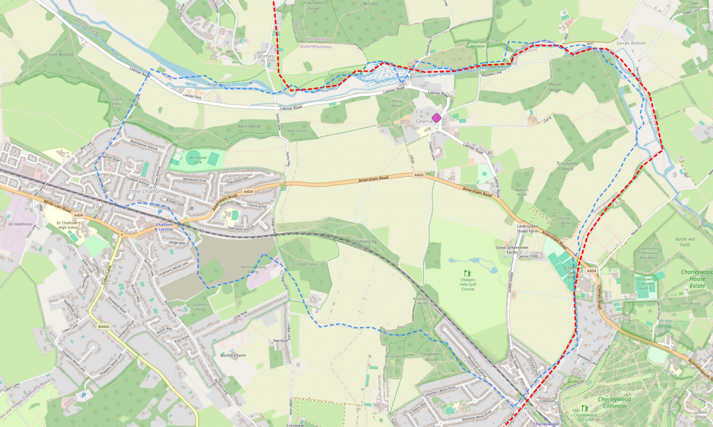
- 15-21 Sheephouses (located at the junction of Amersham Road and Chessfield Park (see below map)
- 23 School House adjacent to school
- 24-28 Claypits Cottages
- 33-42 Alms Houses (no longer in existence)
- 43 Great Greenstreet Farm
- 44 Little Greenstreet Farm
- 47 Mountwood Farm
- 78 The Goat (replaced by The Lodge)
- 103 The Red Lion
- 106 The Manse
- 107 White House (now the Old Rectory)
The original Chenies parish boundary, which includes a lot of what is now in Little Chalfont, can be seen on the map below.
Take a look through the census and let us know if you have information which identifies your property: 1851 Chenies Census
content source: Chorleywood Field Studies Centre
contributor: Andy Homewood, Tony Evans
date published: 1/11/2025